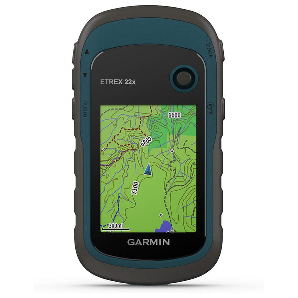


Garmin GPSMAP 65s Handheld GPS Navigator
- Large 2.6” sunlight-readable color display for easy viewing
- ABC SENSORS: Navigate every trail with ABC sensors, including an altimeter for elevation data, barometer to monitor weather and 3-axis electronic compass.
- Compatible with the Garmin Explore website and app (compatible smartphone required) to help you manage tracks, routes and waypoints and review statistics from the field
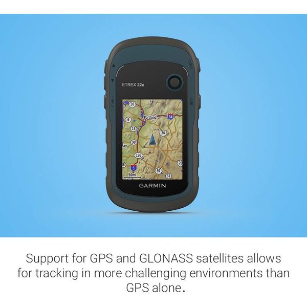
- Multi-Band/Multi-GNSS Support
- Preloaded TOPOActive AU Maps
- Smart Notification
Product Description:
Explore more with this rugged handheld that offers optimal tracking accuracy, a 2.6-inch colour display and preloaded maps. Don't miss a detail with this large, sunlight-readable color display. Lead the way in challenging locations with multi-band technology and expanded GNSS satellite support. Cross the countryside with routable TopoActive maps. Venture confidently. This rugged handheld is built for tough environments. Organise your adventure from anywhere with the Garmin Explore website and app. Travel with up to 16 hours of battery life in GPS mode.
EXPANDED GNSS SUPPORT
Multi-band technology and expanded GNSS support (GPS, GLONASS, Galileo, QZSS and IRNSS) provide optimal accuracy in steep country, urban canyons and forests with dense trees.

PRELOADED TOPOACTIVE MAPS
Preloaded TopoActive maps provide detailed views of routable street and off-road networks, waterways, natural features, land use areas, buildings and more.
SMART NOTIFICATIONS
Receive emails, texts and alerts right on your handheld when paired with your compatible device.
GARMIN EXPLORE APP
Plan, review and sync waypoints, routes and tracks by using the Garmin Explore app and website. You can even review completed activities while still in the field.

MICROSD SLOT
Using your compatible device and microSD memory card, conveniently download TOPO 24K maps and hit the trail, or access HuntView Plus maps to see public land types and boundaries as well as private landowner names and boundaries.
GEOCACHING
Get automatic cache updates from Geocaching Live, including descriptions, logs and hints.
General Specifications:
- LENS MATERIAL: chemically strengthened glass
- DIMENSION: 6.1 x 16.0 x 3.6 cm
- WEIGHT: 217 g with batteries
- WATERPROOF: IPX7
- DISPLAY TYPE: Transflective, 65K colour TFT
- DISPLAY SIZE: 3.6 x 5.5 cm; 2.6-inch diagonal (6.6 cm)
- DISPLAY RESOLUTION: 160 x 240 pixels
- BATTERY TYPE: NiMH or Lithium recommended
- BATTERY LIFE: 16 hours
- MEMORY/HISTORY: 16 GB (user space varies based on included mapping)
- INTERFACE: High-speed mini USB and NMEA 0183 compatible
Box Contents:
- GPSMAP 65s
- USB cable
- Carabiner clip
- Documentation
BRAND NEW
12-months Manufacturer Warranty